
2. Harmonisation and Inter-Urban Comparison
Is Chicago’s urban sprawl more pronounced than Mexico City’s? Does the low proportion of vacant spaces in Paris reflect a greater pressure on land there than in Chicago? Which city has seen the most accelerated densification of the built environment recently? In addition to the environmental and social issues, these questions can only be answered by analysing land use and land cover data that are comparable between the three cities over time, which involves the spatial and temporal harmonisation of databases.
There are two distinct approaches to harmonisation. One, thetop-downapproach, consists in describing land cover using homogeneous criteria and identical sources. These are identified either for the entire planet or for a given regional area principally through the use of satellite products (i‧e. the Global Land Cover Facility databases, Global Land 30 or Corine Land Cover). The spatial resolution (ranging from one kilometre to just a few metres) and temporal sampling of these sources provide an initial overview of the main land covers for the three studied cities and their dynamics. However, the nomenclatures often lack thematic precision because they distinguish only land cover and not land use. As such, they are inadequate for describing urban spaces beyond a two-dimensional presentation of the urban site’s overall shape and spread (Esch et al., 2013).
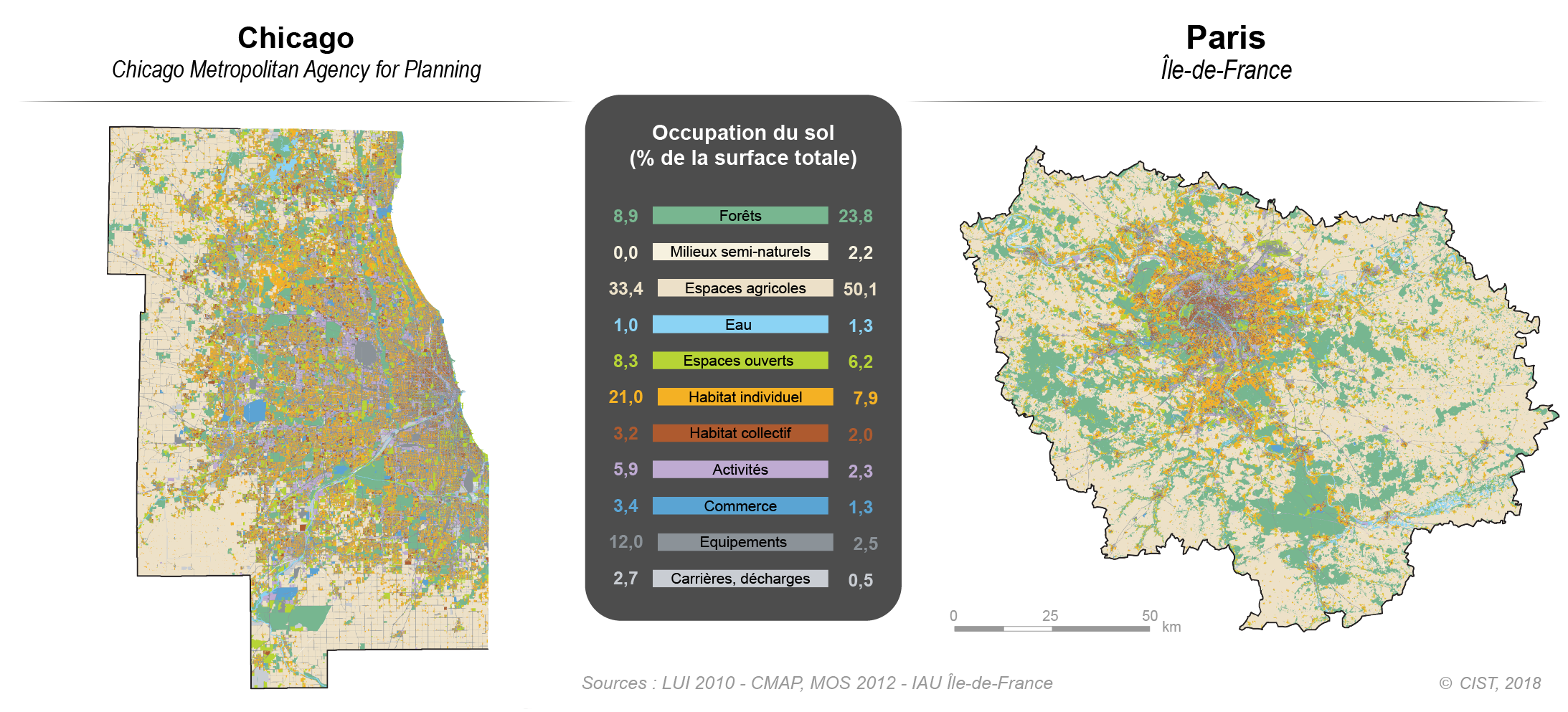
To improve the thematic richness and to zoom in at local observation level, the second,bottom-up), consiste à établir des correspondances a posteriori entre des nomenclatures très détaillées, construites pour des territoires particuliers, à partir d’une résolution adaptée à l’échelon cadastral : en l’occurrence, le MOS (mode d’occupation des sols) de l’IAU ÎdF pour la métropole parisienne (81 postes, au plus fin) et les données ouvertes du CMAP Chicago Metropolitan Agency for Planning pour Chicago (60 postes ; qui ne recouvrent pas l’ensemble du Chicagoland). Ces données ont une précision géométrique dans les deux cas de 1/5 000 et sont disponibles à plusieurs dates, ce qui permet d’analyser l’évolution temporelle des occupations et utilisations des sols. Malheureusement aucune donnée de ce type n’était disponible pour Mexico.
The contents of these two nomenclatures are far from identical. They each reflect the cultural, land and administrative logics specific to the city in question. For example, open spaces are described in the CMAP database in terms of recreational or conservational use, while the MOS elements seem to be based more on a description of vegetation formations. Local particularities are also evident, such as the MOS’s ‘allotment/community garden’ class, which does not seem to have any equivalent in the CMAP typology.
A thematic aggregation of the data from the initial metropolitan databases (on a reduced number of posts), which inevitably means a certain loss of information, results in a harmonised typology of land use and land cover for the two cities (Fig. 2). This typology comprises 11 classes and a finer spatial and thematic resolution than the aforementioned global databases. It thus allows us, for example, to compare the proportions and spatial distributions of individual housing units, which are the dominant housing type in the Chicago metropolitan area, occupying 2.7 times more surface space than in the Île-de-France region.
This alignment work also makes temporal analyses possible when data from the longitudinal monitoring of a database are available (as is the case with MOS between 1982 and 2012) or when correspondence tables are available (as they are for the CMAP database between 2005 and 2013). The initial categories can also be retained to zoom in on certain classes where direct correspondence is possible (for example vacant land if we are interested in their evolution in connection with high land pressure).